


Le Beaucet

micheldutilleul
User
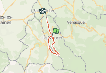

Length
8.1 km

Max alt
394 m

Uphill gradient
180 m
Km-Effort
10.8 km

Min alt
178 m

Downhill gradient
249 m
Boucle
No
Creation date :
2022-08-06 08:27:47.081
Updated on :
2022-08-06 10:23:07.802
1h40
Difficulty : Medium

FREE GPS app for hiking
 SityTrail
IGN / Geographical institutes
SityTrail Plus
The world is yours!
About
Trail Walking of 8.1 km to be discovered at Provence-Alpes-Côte d'Azur, Vaucluse, Le Beaucet. This trail is proposed by micheldutilleul.
Description
Balade qui passe par les ruines du château de Beaucet, quelques maisons troglodytes et dans les bois.
Attention, la moitié de la balade est sur les hauteurs et en plein soleil.
Positioning
Country:
France
Region :
Provence-Alpes-Côte d'Azur
Department/Province :
Vaucluse
Municipality :
Le Beaucet
Location:
Unknown
Start:(Dec)
Start:(UTM)
669920 ; 4872189 (31T) N.
Comments